

ANSTO’s study of the Perth Basin aquifers determined the age of groundwater to be 23,000 to 35,000 years old. Although this result was expected, what was surprising was the identification of an area of younger modern groundwater at a depth of 300 metres below ground level.
This area is of prime interest for water resource managers because fresh water is replenishing the otherwise isolated underground system.
The Gnangara groundwater system is the largest utilised source of groundwater in the southwest of Australia and supplies up to 70% of Perth’s potable water during periods of drought. Its sustainable use is crucial for future development in and around Perth.
Naturally occurring radioactive isotopes such as tritium and radiocarbon are ideal tools to date the groundwater. By understanding the age of the groundwater, we can then determine how frequently the water is being replenished and how much of the resource is available for use.
Strong competition for this limited water resource means that understanding its hydrology is essential for sustainable groundwater management.
The Gnangara Mound and Groundwater System
The Gnangara groundwater system covers an area of approximately 2,200 km2 and constitutes the largest utilised source of groundwater in the southwest of Australia (Fig. 1).
These aquifers can supply up to 70% of Perth’s potable water when river water is not available (such as during drought periods) and its sustainable use is of major importance for future development in the Perth Basin.
Aquifers are rock structures or sediments located beneath the ground that are saturated and permeable enough to allow economic quantities of groundwater to be extracted. Groundwater from these vast aquifer systems support agriculture, industry and private domestic use, and also sustain significant groundwater dependent ecosystems that carry social, cultural and environmental values.
There is increasing pressure on this supply, resulting from irrigation demands and urban development. Strong competition for this limited water resource, along with warmer weather and a decrease in rainfall from climate change has led to reduced groundwater levels.
Information obtained from the analysis of stable isotopes of O, H and C, and the radioactive isotopes of C and H, used together with hydrochemical information, provides the necessary tools for understanding groundwater age and hence recharge patterns within this large water resource system.
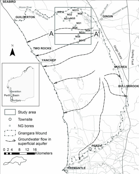 |
| Location Map of the North Gnangara Mound study area with well locations and generalised groundwater flow direction for the Gnangara Mound |
How is ground water dated?
It is important to understand how frequently water is being replenished in the aquifers. This can be achieved by determining the age of the water, and to do this we use two naturally occurring radioactive isotopes that are found in water. Tritium, 3H is a short-lived isotope of hydrogen with a half-life of 12.43 years. It forms part of the water molecule and therefore can be used to directly date the water. Radiocarbon dating is the most accessible and widely used technique to date ‘older’ groundwater resources.
Radiocarbon (14C) is the radioactive isotope of carbon and has a halflife of around 5,700 years. It is produced naturally in the atmosphere by cosmic rays and is subsequently oxidised to CO2, where it mixes into the lower atmosphere and is then incorporated into the biosphere and hydrosphere. The ubiquity of carbon in groundwater makes it an ideal isotope for dating groundwater.
Dating groundwater using radiocarbon (14C) is complicated by the fact that the carbon may come from a variety of sources of different ages, for example some
carbonates may come from very old sources and contain no radiocarbon. The presence of this ‘dead’ carbon must be corrected for, in order to get a reliable age. This can be overcome by accounting for the major hydrochemical and physical processes that are likely to influence the carbon chemistry of a groundwater sample [1].
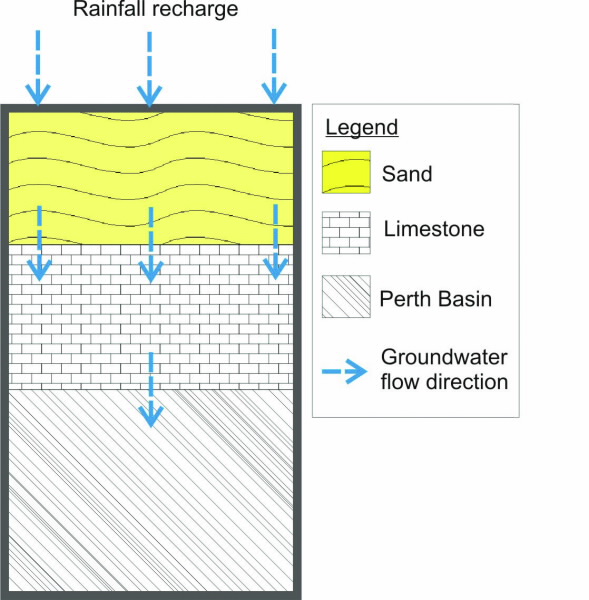 |
| Groundwater recharge path into the Perth Basin aquifers through the sandy aquifer and carbonate unit. |
How do we analyse groundwater chemistry and isotopes?
The chemical composition of water samples is measured by inductively coupled plasmaatomic emission spectroscopy for cations and ion chromatography for anions. Stable isotopes of dissolved inorganic carbon (δ13CDIC) are analysed by liberating CO2 from each sample and injecting it into an isotope ratio mass spectrometer. For 3H analysis, water samples are distilled and electrolytically enriched prior to being analysed by the liquid scintillation method.
For 14C analysis, the total DIC (dissolved inorganic carbon) is processed into CO2 by acidifying the samples and extracting the liberated CO2 gas using a custom-built extraction line. The 14C activities were measured by accelerator mass spectrometry using ANSTO’s 2MV tandetron accelerator, STAR.
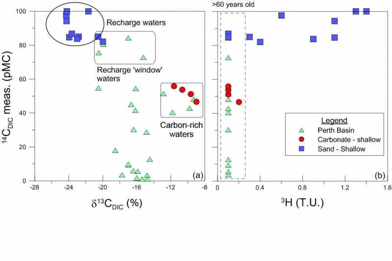 |
| Bivariate plots of measured 14C activity vs. (a)13CDIC and (b) 3H activity. |
Groundwater recharge and carbon evolution
Hydrochemical variability was observed in groundwaters abstracted from the different aquifers within the Gnangara groundwater system [2]. Fig. 2 shows the recharge path of rainfall and/or river waters through the various aquifer units until it forms groundwater in the interconnected pores of the sand and limestone units. Once groundwater from these units reaches the Perth Basin aquifers (located more than 200 m below the ground surface) they generally form palaeowater or old groundwater.
The groundwater is recharged by rainfall which passes through the soil zone, and dissolves carbon on the way. Thus, groundwater in the sandy aquifer inherits a δ13CDIC, which is similar to the signature of soil zone CO2 (i.e. ~25%). Groundwater from this unit also had high measured 14C activities (70 to ~100 pMC) and detectable 3H activities (Fig. 3) indicating exchange with the 14C-active soil zone, leaving it open to modern carbon exchange.
Groundwaters originating from the overlying sandy aquifer have high concentrations of CO2 liberated from the oxidation of organic matter. As this acidic recharge enters the carbonate aquifer, dissolution is enhanced. Consequently, groundwater pH, Ca2+ concentration and δ13CDIC values increase (Fig. 4). Groundwaters also move towards carbonate saturation further implying a shift from open to closed system conditions.
Groundwater infiltrating through limestone units such as these found in Gnangara, can have up to 50% of its HCO3 - contributed from a ‘dead’ carbon source making the waters appear older. Therefore, uncorrected radiocarbon results can appear much older and are not considered representative ages in this groundwater environment.
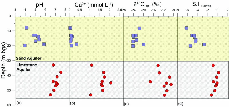 |
| Bivariate plots of depth vs. (a) pH (b) Ca2+ (c) 13CDIC and (d) saturation indices for calcite for groundwaters from the top ~60m of the study areas. |
Identification of recharge areas within the Gnangara Mound
Radiocarbon corrections were applied to all groundwater samples according to the main hydrogeochemical processes identified [3]. The corrected radiocarbon ages of groundwater from the Perth Basin aquifers were generally found to be old (23,000 to 35,000 years old). However, in the south-eastern corner of the study area (sites NG03 and NG09, see Fig.1) they were much younger than anticipated, ranging from modern to ~2,000 years old. Fig. 5 is a geological cross-section running east to west through the study site showing the location of younger groundwaters recharged into the Perth Basin.
This is occurring where low permeability units are not present, forming a recharge ‘window’. The identified recharge area is of prime interest for water resource management because not only is it important that it is left to actively recharge fresh water into the deep aquifers, but it also needs to be protected from point-source contamination. For example, application of pesticides to soils in this area could lead to a higher risk of contamination in an otherwise protected groundwater resource.
Identification of areas of recharge into confined aquifers is important for managing water allocations and will help with calibrating physical hydrogeological models of a groundwater system. The understanding of aquifer interaction in this area is crucial to sustainable management of confined aquifer abstraction in a drying climate.
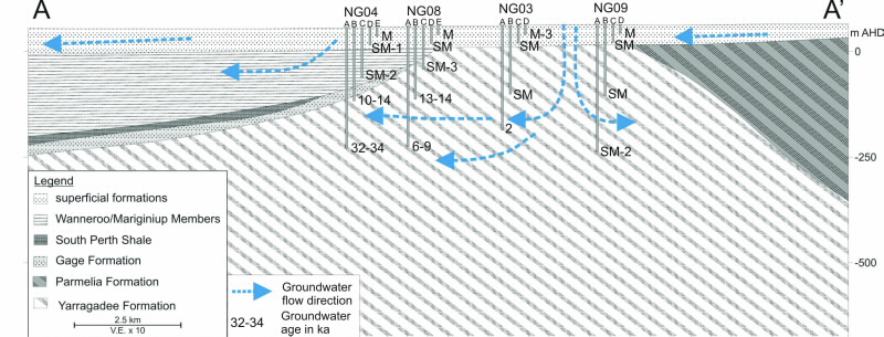 |
| Geological cross-section with corrected groudnwater age and flow direction (arrows) for the study site (refer to Figure 1 for cross section location A-A'). M= modern (<60 years old) and SM (>60 but <1,000 years old) |
Acknowledgements
The authors would like to thank the Government of Western Australia, Department of Water (DoW) for providing the funding and support for this project. Thank you to Geoff Sadgrove from DoW for his field work contribution and technical assistance.
 |  |
Authors
Karina Meredith1, Dioni I. Cendón1, Jon-Philippe Pigois2, Suzanne Hollins1, Geraldine Jacobsen1Authors
1ANSTO, 2Government of Western Australia, Department of Water
References
- Kalin, R.M., Radiocarbon dating of groundwater systems. In: Cook P.G., Herczeg A.L. (Ed.) Environmental tracers in subsurface hydrology. Kluwer, Boston, pp 112–144 (1999).
- Meredith, K., Cendón, D., Hollins, S. North Gnangara Groundwater Dating, Western Australia. A report prepared for The Government of Western Australia (WA), Department of Water. ANSTO/C-1084 (2010).
- Meredith, K., Cendón, D.I., Pigois, J.-P., Hollins, S., Jacobsen, G., Using 14C and 3H to delineate a recharge ‘window’ into the Perth Basin aquifers, North Gnangara groundwater system, Western Australia, Science of The Total Environment, 414, 456-469 (2012).
Published: 10/07/2012