

Severe bushfires, such as Australia’s 2009 Victorian ‘Black Saturday’ bushfires, expose the soil in bushland. Subsequent high intensity storms – possibly once-in-a-hundred year events – can then cause significant erosion with massive debris flows. This can happen even in small creek systems.
This study used fallout radionuclides (radioactive atoms) as tracers to better understand the processes that influence the evolution of landscapes experiencing these events.
The fate of the forest soil is particularly important because it can tell us whether or not existing conditions are sustainable. For example, if severe bushfires followed by severe storms causes soil depletion, we know there will be damage to the soil and subsequently, the forest, rather than a sustainable equilibrium.
Fallout plutonium isotopes, measured at trace levels using the ANTARES accelerator, were used for the first time in this kind of study.
Study area
The upper part of Myrtle Creek, in the Ovens River basin of North East Victoria, forms a small 23 hectare catchment, covered in dry open eucalypt forest (see map, Fig. 1). This area was completely burnt by one of the numerous high severity bushfires which swept Victoria in February 2009.
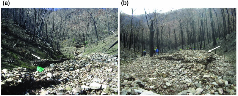
In the first few days of March 2009, several storm cells passed over the catchment, producing short duration, high intensity rainfall (around 50 mm per hour rainfall rate). Even in a small catchment such as Myrtle Creek, the water pouring off the hillsides into the creek generated significant debris flows, moving hundreds of tons of material including gravel, sediments, tree trunks and small boulders (see Fig. 2).
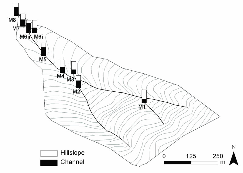 |
| Fig 1. Contour map of the Myrtle Creek catchment, ranging in elevation from 430 to 770m. Sampled sediment deposition sites are shown, with the relative contribution from hillslope and channel bank source contributions. |
Fallout radionuclides as tracers
Fallout from atmospheric nuclear weapons tests, carried out mainly in the late 1950s and early 1960s, distributed radionuclides all around the world. Certain longer lived radionuclides remain where they fell, in soil, sediments and elsewhere in the environment. These radionuclides act as markers in the soil or sediment and can then be used to trace the movements of such material.
Of these, 137Cs fallout has been used widely in erosion studies, as it tends to be firmly attached to the fine particles in soil or sediment. 137Cs has a half-life of 30 years, so this marker is diminishing as the years go by. Plutonium, in particular 239Pu and 240Pu, also forms a major component of fallout and, like caesium, binds well to fine particles.
With half-lives of several thousand years, the fallout signal from Pu isotopes provides a long-term marker in soils and sediments. Plutonium has only recently been used in this kind of work [1], as a result of the recent development of accelerator mass spectrometry for actinides. In the present study, both caesium and plutonium were used.
Sampling and measurements
137Cs can be measured by gamma spectrometry in large samples. Pu is not detectable in this way, but can be measured with high sensitivity, even in small samples, by accelerator mass spectrometry. For this work, the Pu isotopes were measured using ANSTO’s ANTARES accelerator. We could easily measure samples with 0.1 picogram of Pu per gram of soil.
Three different types of locations in the catchment were sampled:
- Hillslope surface soils, to identify typical material which may contribute to downstream deposition. These samples had the highest levels of fallout radionuclides.
- Channel banks. As the creek floods, it cuts into the banks and stream bed, deepening the watercourse.
- Hence, material from the banks is swept into the flow and is also deposited downstream. These samples are comprised of sub-soil material and contain the least amount of fallout.
- Deposits were sampled, such as levees left behind at the height of the storm flow. In all cases, we extracted fine sediments from the sampled material for our measurements.
Results
Fig. 3 shows that caesium (137Cs) and plutonium (239Pu+240Pu) are well-correlated, confirming that plutonium is as valid as the more commonly used caesium for sediment tracing. As expected, the highest and the lowest activities are seen, respectively, in the hillslope and the channel bank samples.
The activities of the deposits fall in between; the relative contributions to each deposit site sampled can be derived from a simple mixing model with relative contributions shown on the map in Fig. 1.
Further study of the results with respect to the types of locations sampled shows that hillslope erosion is the major contributor to sediment deposition during the peak of the storm. Subsequent deposition, following the peak flow, accumulated in inner channel deposits and in the terminal fan, is dominated by channel bank sourced material.
Carbon dating, using the STAR accelerator, has also been performed on past debris flows at Myrtle Creek.
These show that severe erosion events, such as those observed here in 2009, might occur at intervals of several hundred years in susceptible locations. In combination, these observations allow conclusions to be drawn about the erosion processes occurring at this site.
Despite the low frequency of these events, the results indicate that they are major contributors to the long-term erosion of forest soils. Although the data here are limited, there are indications that the erosion rate exceeds the soil formation rate in this situation, leading to net soil loss. Soil loss leads to long-term environmental impacts.
This study, along with that of another site in Victoria, is reported in detail in a recent issue of the journal Geomorphology [2].
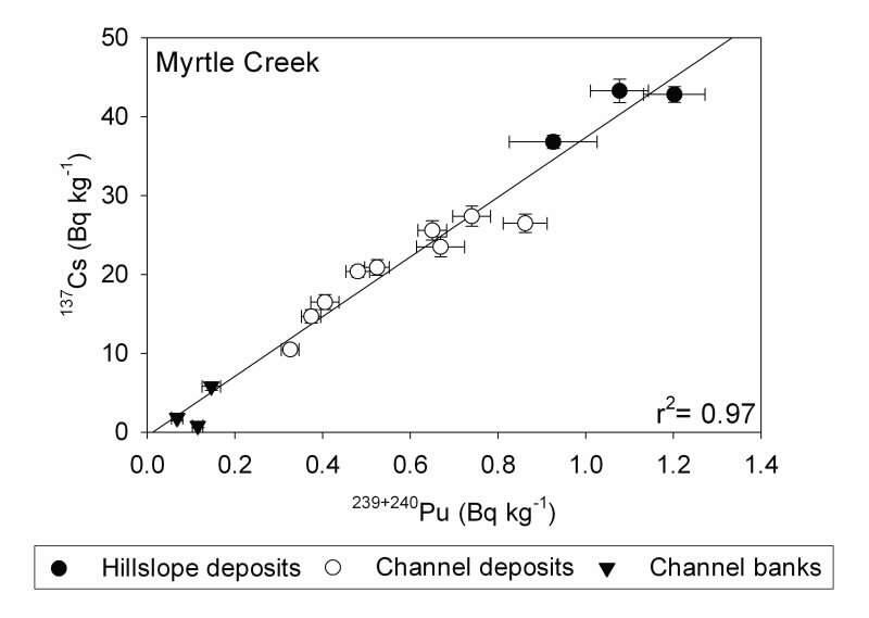 |
| Fig 3. 137Cs and 239+240Pu activities of samples from the Myrtle Creek catchment. |
Authors
Michael Hotchkis1, Hugh Smith2,3, Gary Sheridan3, Petter Nyman3, Patrick Lane3, David Child1, Geraldine Jacobsen1
1ANSTO, 2University of Plymouth, UK, 3University of Melbourne
References
- Everett, S. E., Tims, S. G., Hancock, G. J., Bartley, R. and Fifield, L. K., Comparison of Pu and 137Cs as tracers of soil and sediment transport in a terrestrial environment. J. Environ. Radioact. 99, 383-393 (2008).
- Smith, H.G., Sheridan, G.J., Nyman, P., Child, D.P., Lane, P.N.J., Hotchkis, M.A.C., and Jacobsen, G.E., Quantifying sources of fine sediment supplied to post-fire debris flows using fallout radionuclide tracers, Geomorphology 139–140, 403-15 (2012).