

Given the importance of water in Australia, surprisingly, there is relatively little information about the past variability of rainfall on this continent. Although there is a good annual record of the past 100 years in Australia, there is nothing much before that period and no known cave deposit records exist for New South Wales.
 |
| Researchers working in underground caves studying when rainfall reaches the subsurface at Yarrangobilly Caves in the Snowy Mountains have found new information that will help reconstruct past climates. |
ANSTO, University of New South Wales (UNSW) Australia and the National Parks and Wildlife Service (NPWS) have collaborated on research, which appears in the Journal of Hydrology (Markowska et al. 2015). The group is interested in interpreting the rainfall record of the past 2000 years in Australia, because understanding past climate can help predict the availability of water resources in the future.
The study is taking place in the Snowy Mountains, which are an important study site as the area provides an important source of water for the Murrumbidgee and Murray River systems, two major waterways in southeast Australia. The limestone deposit contains a system of about 400 caves managed by the NPWS. Geologists suggest that the caves were formed about 440 million years ago.
Researchers working in underground caves studying when rainfall reaches the subsurface (groundwater recharge) at Yarrangobilly Caves in the Snowy Mountains have found new information that will help reconstruct past climates and groundwater recharge from cave deposits. Cave deposits, or speleothems, are mineral accumulations formed by calcium-rich water in underground caverns. They are important because they can be used to establish a record of past environmental changes, such as rainfall variability.
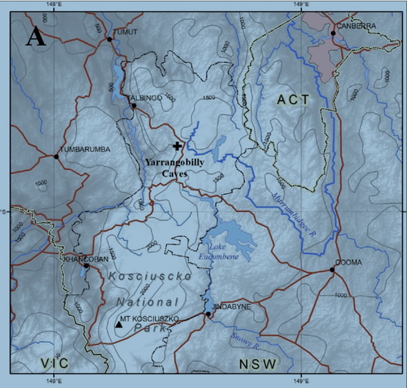
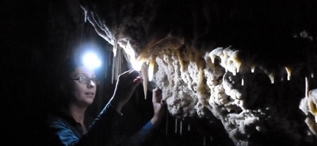
Lead author, Institute for Environmental Research scientist Monika Markowska and colleagues have been monitoring dripping water, which forms stalagmites, for fifteen months in the cave system, which is located in Kosciuszko National Park.
“Monitoring the water movement from the surface to the cave is important because it carries the majority of the climate and environmental information from the surface,” according to Prof Andy Baker of UNSW Australia, a co-author on the paper.
In this study researchers found that the soil moisture content may be more important than the amount of rainfall in the formation of stalagmites.
“Although rainfall is essential for groundwater recharge, at Harrie Wood Cave it was the antecedent soil moisture saturation (i.e. wet or dry preconditions) that controlled whether water from individual rainfall events reached the underground cave system.” said Markowska.
The research team came to this conclusion after a detailed analysis of drip water flow at 14 sites within the Harrie Wood Cave taken at 15-minute intervals and weather data from the surface above the cave. By monitoring drip rates, researchers can determine how long it took the water to get into the cave. They also monitored precipitation, temperature, barometric pressure and soil moisture.
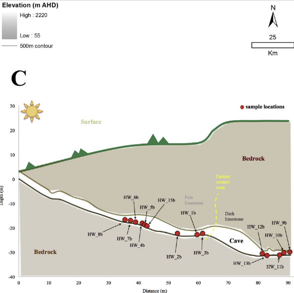
In the cave, dripping water was automatically recorded using Stalagmate® drip logger, devices similar to a miniature, watertight, plastic drum that records each drip from the vibration measured each time a water droplet hits its surface. The data from 14 sites reported in the paper are part of a network of fifty devices placed in the cave, one of the largest such studies in the world. Interpreting the data provided by the Stalagmate® loggers provided a unique way to classify and understand water flow from the surface to the cave.
The researchers identified five different types of drip water responses to surface climate and were surprised to see different flow patterns in drips in close proximity to each other.
The five types of response are due to the many possible water flow paths from the surface to the cave, with water potentially stored in both the soil and in fractures and solution pockets in the limestone, before reaching the cave.
Most importantly, the research demonstrates that speleothems can have very individual relationships to the surface climate due to the specific water flow route. This information has allowed researchers to identify which speleothems can be used to obtain a rainfall record for the past 2000 years.
Stalagmites, a speleothem, are important because they can be analysed using mass spectroscopy to determine records of past climate.
The decay of uranium-234 into thorium from the calcite in a stalagmite can be measured to determine age. The ratio of oxygen-18 and oxygen-16 can provide information about rainfall.
Link to journal article: doi:10.1016/j.jhydrol.2014.12.044
Published: 05/05/2015