Recent climate predictions suggest Australia will experience more high-intensity tropical cyclones and flooding leading to extensive economic and social disruption.
These predictions are based on modelling global warming scenarios using short-duration historical cyclonic records. In order to improve future modelling of cyclone frequency, we need to find evidence of extreme events occurring over the past few tens of thousands of years.
At Jacks Waterhole, a narrow gorge about 500 m wide along the Durack River, in the Kimberley region of north-west Australia, numerous sets of meter-sized, mega-ton boulders are found stacked into semi-circular piles.
These piles of imbricated boulders are due to massive storms and floods occurring during the past when rainfall conditions were vastly different from today. Using the novel technique of in situ cosmogenic-exposure dating and ANSTO’s Accelerator Mass Spectrometry ANTARES Facility, ANSTO scientists were able to measure the time when these massive boulders were plucked from bedrock and flipped into piles.
Initial results indicate that mega floods in the Kimberley region occurred about 15,000, 130,000 and 250,000 years ago - exactly during the period when earth’s climate was changing rapidly at the end of the last 3 major ice ages.
During these periods, sea-surface temperatures were increasing leading to increased atmospheric moisture supply and sea level rise associated with polar-ice melt. These results indicate that rapid increase of global temperature and future increases in global sea-level, may increase the magnitude of tropical cyclones and extreme flood events.
Assessing the floods
Australia has recently experienced a series of catastrophic floods associated with tropical cyclones and storms. While enhanced rainfall potentially helps agriculture to recover from long-standing drought, it can cause tremendous damage to urban communities and natural environments. Assessing risks of such hazardous events is of significant public concern in terms of the sustainable use of resources under our current rapidly changing climate.
There have been numerous investigations on how current global warming affects the occurrence of tropical cyclones and thus flood events [1], but the outcome is somewhat controversial.
Although tropical cyclone activity appears to have increased in Australia over the past decade, the short nature of the historical and instrumental records prevents climate scientists from unambiguously decoupling the anthropogenic influence from the natural cyclone systems, thus making future predictions difficult.
In this study, we determined the timing of extreme floods in the monsoon tropics of Australia that displaced and overturned massive boulders plucked from underlying bedrock. The dating technique utilises the measurement of the concentration of the long-lived radioactive nuclide, 10Be (half-life ~1.39 million years), which is produced in Earth’s surface rocks via continuous bombardment of cosmic-ray particles.
We applied this technique to imbricated clusters of gigantic boulders at Jack’s Waterhole along the Durack River in the Kimberley in northern Australia.
 |
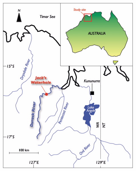
| Fig 1. Location of the massive flood-generated boulder site at Jack’s Waterhole in the Durack River, the Kimberley, northern Australia; the exposed and hidden surfaces of six boulders were sampled for dating of mega floods using cosmic-ray-produced radionuclide 10Be. |
The study site
The Kimberley belongs to the monsoon tropics of northern Australia; its climate is highly seasonal ranging from tropical to semi-arid where the region receives 90% of annual rainfall during the summer monsoon period (November–April). Occasional, but often intense, storms and cyclones lead to river flooding causing one of the main natural hazards for the local population.
Jack’s Waterhole is located in the middle to lower sections of the Durack River, about 70 km upstream from its outlet to the Cambridge Gulf (Fig. 1). The flow derived from the upper catchment of 12,000 km2 is funnelled through a narrow gorge, 500 m wide and ~1.5 km long, which has been formed by long-term incision of the Durack River into resistant sandstone.
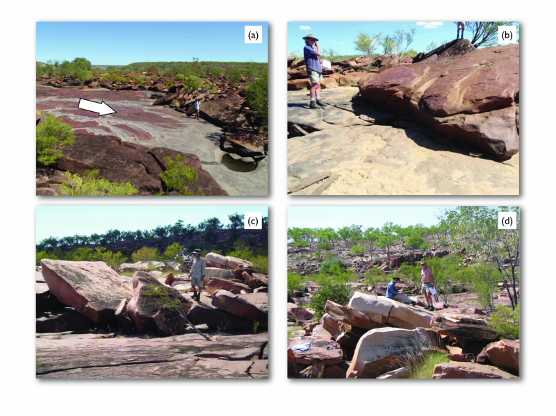
Along the flanks of the gorge and slightly above the modern river channel, numerous hydraulically-plucked rock slabs have been stacked into discontinuous, semi-circular patterns of imbricated piles that resemble toppled rows of dominoes (Fig. 2a-d). Based on surface erosional features (e.g., weathering pits, smoothness, rock vanish coating) and freshness of joint breaks and fracturing, some of these boulders have clearly been overturned.
The layered bedding matrix of sandstone results in platy boulder shapes of a few to several metres in the long-axis and 0.5 to 2 m thick. The blocky quasi-square nature of the boulders results from the vertical jointing of the local bedrock.
A hydrological and channel morphological study of the site by Wende [2] suggested that only extreme floods with exceptionally high-flow velocities of up to 10 m/ sec can dislodge and move these massive boulders. Such climatic events have not been documented in the palaeoclimate and environmental archives since the mid-Holocene (past 5,000 years), and we speculate that the overturning events may result from major changes in global climate associated with the waxing and waning of past ice ages. But, how can we ‘date’ when a boulder flipped?
 |
| Fig 2. (a) View looking upstream of a portion of the field of massive imbricated boulders at Jack’s Waterhole. White arrow represents flow direction. (b) Prof Gerald Nanson next to boulder JW-1 (surface area 5.5 x 5 m, thickness ~70 cm, weight ~20 t), which was sampled on upper and lower surfaces for 10Be that gave a model overturning age of 11,400 years. (c) David Fink next to imbricated boulder clusters. The boulder at the extreme left (JW-2, surface area 3.5 x 3.5 m, thickness ~70 cm, weight ~20 t) was sampled for 10Be that gave an overturning age of 140,000 years. (d) Toshi Fujioka (left) and Gerald Nanson (right) on boulder JW-5 (surface area 7 x 3 m, thickness ~1 m, weight ~50 t). The boulder is among the largest we sampled thatgave the oldest overturning age of 235,000 years. |
From the image represented above, (b) Prof Gerald Nanson next to boulder JW-1 (surface area 5.5 x 5m, thicknss ~70cm, weight ~20t), which was sampled on upper and lower surfaces for 10Be that gave a model overturning age of 11,400 years. (c) David Fink next to imbricated boulder clusters.
The boulder at the extreme left (JW-2, surface area 3.5 x 3.5m, thickness ~70cm, weight ~20t) was sampled for 10Be that gave an overturning age of 140,000 years. (d) Toshi Fujioka (left) and Gerald Nanson (right) on boulder JW-5 (surface area 7x 3m, thickness ~1m, weight ~50t). The boulder is among the largest we sampled that gave the oldest overturning age of 235,000 years.
Model concept
Cosmogenic 10Be is produced via a spallation nuclear reaction of secondary cosmic-ray particles (neutrons and muons) on oxygen atoms within the mineral quartz (SiO2 is the most abundant mineral on Earth) in rocks.
The longer the surface is bombarded the more 10Be accumulates. Given that the production rate of 10Be (atoms per gram of quartz per year) is known and the extremely low concentration of resultant 10Be in rocks can be measured by accelerator mass spectrometry, we can calculate the exposure ages of rock surfaces.
In addition, by knowing how the cosmic-ray intensity attenuates with depth in the rock, we can predict a 10Be concentration ‘depth profile’ by simply measuring 10Be in the top few centimetres of rock surfaces. However, when a boulder is overturned, the predictable depth profile no longer applies, and the deviation of the predicted value from the measured one can be used to estimate the time when it overturned.
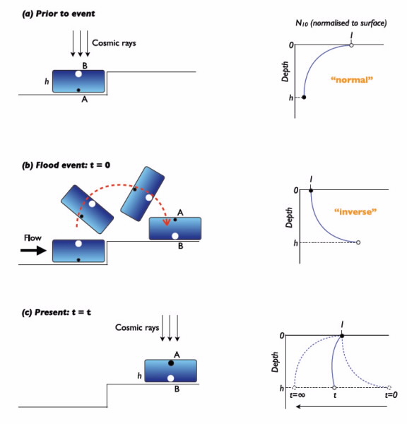
We sampled both the upper (exposed) and lower (hidden) surface of six boulders deemed to have been overturned by field observation. If our identification is correct, the previously buried surface is now exposed and the previously exposed surface is now buried after the event (Fig. 3), making the 10Be ratio of the two surfaces deviate from the predicted value.
Immediately after the event, the 10Be concentration of the now hidden surface (i.e., the previously exposed surface) must exceed that at the exposed surface (i.e., the previously buried surface) (Fig. 3b).
This inverse relationship will, with time, gradually tend to revert to the normal relationship (i.e., as if the boulder had never overturned) as the current upper surface continues to receive a higher cosmic-ray dose (Fig. 3c).
Thus, the longer the elapsed time since overturning, the more difficult it is to uniquely determine whether the boulder has been overturned or not. Our modelling shows that we areable to determine overturning events for the time range between 1,000 to 300,000 years for boulders of 1 m thickness.
 |
| Fig 3. Schematic diagrams of an interpretive boulder-overturning model (left) and associated cosmogenic-10Be vertical depth profiles through the boulder (right). (a) Just prior to the event (designated as t = 0): long-term continual irradiation of the intact boulder has resulted in an exponentially decreasing (“normal”) 10Be concentration profile, which is controlled by the cosmic-ray attenuation rate and boulder thickness, h. (b) At the flood event (t = 0): the upstream face of the rock slab is plucked from its bedrock contact, detached, rotated about a pivot point at its downstream face and overturned, exposing a previously-buried surface (surface A). The 10Be profile immediately after overturning (t ~ 0) will be an inverted curve (“inverse” profile) similar to that given in (a). (c) As the cosmic-ray irradiation time continues, the 10Be profile tends progressively to resemble the “normal” profile (dashed curves). During this time period, prior to re-establishing a “normal” depth profile, the overturning age, t, can be calculated by comparing the ratio of 10Be on the lower to upper surface with that the predicted ratio based on the upper-surface 10Be concentration with boulder thickness. The size of black and white dots denotes the relative difference in the 10Be concentration between the surface A and B. |
Determining the age of floods
Four out of six boulders we sampled show an inverse relationship in 10Be concentrations between their upper and lower surfaces, indicating that they have been overturned. Within our measurement uncertainty, we could not unequivocally determine if the remaining two boulders were overturned. Our model gave overturning ages of 6,300, 11,400, 140,000 and 235,000 years with ~15% uncertainty for the four boulders [3].
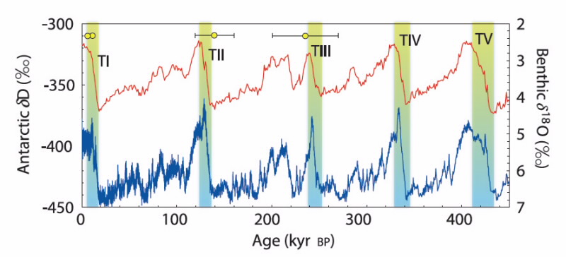
These ages largely coincide with the last three major transitions of global climate from glacial to interglacial periods, termed glacial terminations, i.e., T-I (18,000– 11,000), -II (136,000–124,000) and -III (252,000– 238,000 years ago) [4] (Fig. 4)
These transitions are characterised by a rapid increase in global temperature (~2°C per 1,000 years) associated with sea-level rise in parallel to a reorganisation of atmospheric and ocean circulations. We believe that the relative climatic instability at glacial terminations led to temporal enhancement of tropical cyclone and storm activities, consequently generating devastating floods along northern Australia.
The youngest model age (6,300 years) corresponds to a period of relative warmer and wetter conditions associated with final sea-level adjustment to Antarcticice melt since the last glacial maximum (~20,000 years ago). This is supported by sediment records near Darwin indicating intense floods during early to mid-Holocene with much higher magnitude than those during the last 4,000 years [5].
In summary, we conclude that the palaeo-hydrological regime in northern Australia over the past 250,000 years has responded to the major global climate changes during periods of glacial terminations, as evidenced in this study by massive boulder overturing during increased river flow.
This result has implications for assessing the effect of future global warming on the frequency and magnitude of cyclones and storms in the monsoon tropics of Australia.
 |
| Fig 4. The model overturning ages of the mega-flood-generated boulders at Jack’s Waterhole, the Kimberley, overlayed on major climate records over the past 450,000 years (after [4]). Benthic d18O stack (red curve, representing global deepwater temperature and ice volume); deuterium excess (dD) from the EPICA Dome C ice core, Antarctica (blue curve, representing Antarctic temperature). T-I to T-V (yellow-blue bands) denote glacial terminations. Our model overturning ages (yellow-dots; measurements taken on ANSTO’s ANTARES accelerator) coincide with the three recent terminations which involve major oceanic and atmospheric reorganisation. |
Authors
Toshiyuki Fujioka1, David Fink1, Gerald Nanson2, Charles Mifsud1
1ANSTO, 2University of Wollongong
References
- Knutson, T.R. et al. (2010). Tropical cyclones and climate change. Nature Geoscience, 3, 157-163.
- Wende, R. (1999). Boulder bedforms in jointed-bedrock channels. In: Miller, A.J. and Gupta, A., eds., Varieties of fluvial form, John Wiley and Sons Ltd, 189-216.
- Fujioka et al., in prep. Modelling of massive boulder overturning by palaeo-flood events in the tropics Australia, using in situ cosmogenic 10Be. Quaternary Geochronology.
- Wolff et al. (2009). Glacial terminations as southern warmings without northern control. Nature Geoscience, 2, 206-209.
- Nott and Price (1999). Waterfalls, floods and climate change: evidence from tropical Australia. Earth and Planetary Science Letters, 171, 267-276.


